element14 Community
element14 Community
    Register Log In
  • Site
  • Search
  • Log In Register
  • Members
    Members
    • Benefits of Membership
    • Achievement Levels
    • Members Area
    • Personal Blogs
    • Feedback and Support
    • What's New on element14
  • Learn
    Learn
    • Learning Center
    • eBooks
    • STEM Academy
    • Webinars, Training and Events
    • More
  • Technologies
    Technologies
    • 3D Printing
    • FPGA
    • Industrial Automation
    • Internet of Things
    • Power & Energy
    • Sensors
    • More
  • Challenges & Projects
    Challenges & Projects
    • Design Challenges
    • element14 presents
    • Project14
    • Arduino Projects
    • Raspberry Pi Projects
    • More
  • Products
    Products
    • Arduino
    • Dev Tools
    • Manufacturers
    • Raspberry Pi
    • RoadTests & Reviews
    • Avnet Boards Community
    • More
  • Store
    Store
    • Visit Your Store
    • Choose Another Store
      • Europe
      •  Austria (German)
      •  Belgium (Dutch, French)
      •  Bulgaria (Bulgarian)
      •  Czech Republic (Czech)
      •  Denmark (Danish)
      •  Estonia (Estonian)
      •  Finland (Finnish)
      •  France (French)
      •  Germany (German)
      •  Hungary (Hungarian)
      •  Ireland
      •  Israel
      •  Italy (Italian)
      •  Latvia (Latvian)
      •  
      •  Lithuania (Lithuanian)
      •  Netherlands (Dutch)
      •  Norway (Norwegian)
      •  Poland (Polish)
      •  Portugal (Portuguese)
      •  Romania (Romanian)
      •  Russia (Russian)
      •  Slovakia (Slovak)
      •  Slovenia (Slovenian)
      •  Spain (Spanish)
      •  Sweden (Swedish)
      •  Switzerland(German, French)
      •  Turkey (Turkish)
      •  United Kingdom
      • Asia Pacific
      •  Australia
      •  China
      •  Hong Kong
      •  India
      •  Korea (Korean)
      •  Malaysia
      •  New Zealand
      •  Philippines
      •  Singapore
      •  Taiwan
      •  Thailand (Thai)
      • Americas
      •  Brazil (Portuguese)
      •  Canada
      •  Mexico (Spanish)
      •  United States
      Can't find the country/region you're looking for? Visit our export site or find a local distributor.
  • Translate
  • Profile
STEM Academy
  • Learn
  • Learning Center
  • STEM Academy
  • More
  • Cancel
STEM Academy
Blog How to Predict the Path of a High Altitude Balloon
  • Blog
  • Forum
  • Documents
  • Events
  • Members
  • Mentions
  • Sub-Groups
  • Tags
  • More
  • Cancel
  • New
STEM Academy requires membership for participation - click to join
Blog Post Actions
  • Subscribe by email
  • More
  • Cancel
  • Share
  • Subscribe by email
  • More
  • Cancel
Group Actions
  • Group RSS
  • More
  • Cancel
Engagement
  • Author Author: mikedavis
  • Date Created: 15 Jun 2015 2:51 PM Date Created
  • Views 424 views
  • Likes 1 like
  • Comments 2 comments
  • near_space_balloon_flight
  • high_altitude_balloon
  • altitude
  • launch
  • stem space
  • balloon
Related
Recommended

How to Predict the Path of a High Altitude Balloon

mikedavis
mikedavis
15 Jun 2015

As many of you know, I am working with my colleagues at the City Colleges of Chicago and DePaul University on some high altitude balloon (HAB) launches.  This activity has been funded by NASA, and we really excited to to do some launches, and share our findings.  The STEM Academy is a great resource as we build our experiments.  Today's post, however, is about launching and retrieving a balloon.


We live in Chicago, which has two airports, lots of people, buildings, and a huge lake to the east.  The Federal Aviation Administration (FAA) has some guidelines on balloon launches, and one of them is that we cannot launch a balloon within 5 miles of a commercial airport.  Since what we send up also comes down, we don't want to get our balloon out of the lake or off the top of a very tall building.  In short, the city of Chicago is a terrible launch site.


So what is a good launch site?


That actually has more to do with the landing site.  If we know a few things like, the total mass of the payload, amount of lift, and the type of the balloon, we can make a pretty good prediction about where it will come down.  Ideally it would come down in a field, away from a populated area.  A lot of central Illinois has soy and corn fields, which makes a lot of central Illinois an ideal launch and retrieval site.


Making a Prediction


We use the HABHUB site for making predictions about the landing site of our balloons.  It asks us for:

  • Launch site (including latitude and longitude)
  • Launch altitude
  • Launch time (in UTC)
  • Launch date
  • Ascent rate
  • Burst altitude
  • Descent rate


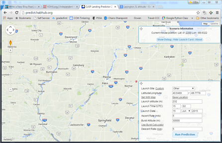
Here I searched on the map for Lexington, IL (a place we commonly launch from) and found its elevation using Google.  The time and date are easy as well.  They are also very useful for trying to determine things a day or two in advance.  Since our vertical flight goes through the jet stream, we can't really count on anything that is more than a couple days away from the actual launch date.  In short, we become more certain about things the closer we get to the launch date and time.


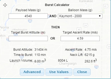
Above you can see the burst calculator for a 2000g gram balloon made by Kaymont.  The target burst altitude or target ascent rate are things that we would try to reach for.  I calculated the ascent rate using another calculator found here.  The result is in feet/min which we convert to meters/sec for this calculator.  As you can imagine, anyone that teaches dimensional analysis or unit conversion would have a field day with this stuff.  There are all kinds of conversions that need to be done.


With this information, we can get a prediction for this flight.


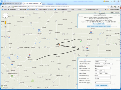
This zig zag motion is pretty common for our flights.  Winds close to the earth and the jet stream will grab the balloon and take it north and east.  Once it emerges from the stream, it will head back west.  After it bursts, and comes back down, it will come east again.  In the end we should expect to collect the balloon close to the I-57 expressway.  When I switch over to Google Maps, I can see that this is in Danforth, IL, and in a farming area.


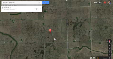
The landing site is pretty good.  Right now, I have now idea what is growing on the field (soy being short is preferable to corn).  But I can see that it is not near a populated area, its not near a river, and it is more than 5 miles from the expressway.  We wouldn't want to come down in a busy road.  Depending on some other factors we may choose to launch a little further to the west so we are further away from the expressway, but for now this looks good.


Students


This is a good place to involve students.  In the days leading up to the launch, we know things like the total weight of our payload (including the parachute), the type of balloon we are using, and how high we would like to go.  At this point our students can become weather experts and start tracking the jet stream.  We use these sites for weather and jet stream information.


  • We use this site for jet stream information.
  • We use this site for local weather.


We will ask our students to do a few predictions with slight changes in payload, ascent rate, and burst altitude to see what the effect it has on the landing site.  When it comes time to pack up the van and go, we want to be sure that our students are very confident of where things will be going.


Next Post


In my next post, I plan to write about tracking a balloon while it is in flight.  Assuming this goes well, I will also probably write about how our launch went.

Anonymous

Top Comments

  • fisher0251
    fisher0251 over 7 years ago +2

    I used HABHUB for predicting the flight of a balloon launched this spring in central MN with a group of my seniors. It was spot on. Happy launching!

  • DAB
    DAB over 7 years ago +1

    Nice post.


    Now you know why NOAA uses the balloon sensor system to get a reasonable idea of the 3 Dimension interactions of the atmosphere.


    There are a lot of cross currents where the winds blow in completely…

  • fisher0251
    fisher0251 over 7 years ago

    I used HABHUB for predicting the flight of a balloon launched this spring in central MN with a group of my seniors. It was spot on. Happy launching!

    • Cancel
    • Vote Up +2 Vote Down
    • Reply
    • More
    • Cancel
  • DAB
    DAB over 7 years ago

    Nice post.


    Now you know why NOAA uses the balloon sensor system to get a reasonable idea of the 3 Dimension interactions of the atmosphere.


    There are a lot of cross currents where the winds blow in completely different directions within the same air volume.


    It looks like you have a good start at the tools you need to find out what is going on.


    You might want to find out when the local measurements are done so you have the best information for your launch time.


    DAB

    • Cancel
    • Vote Up +1 Vote Down
    • Reply
    • More
    • Cancel
element14 Community

element14 is the first online community specifically for engineers. Connect with your peers and get expert answers to your questions.

  • Members
  • Learn
  • Technologies
  • Challenges & Projects
  • Products
  • Store
  • About Us
  • Feedback & Support
  • FAQs
  • Terms of Use
  • Privacy Policy
  • Legal and Copyright Notices
  • Sitemap
  • Cookies

An Avnet Company © 2022 Premier Farnell Limited. All Rights Reserved.

Premier Farnell Ltd, registered in England and Wales (no 00876412), registered office: Farnell House, Forge Lane, Leeds LS12 2NE.

ICP 备案号 10220084.

Follow element14

  • Facebook
  • Twitter
  • linkedin
  • YouTube