element14 Community
element14 Community
    Register Log In
  • Site
  • Search
  • Log In Register
  • Community Hub
    Community Hub
    • What's New on element14
    • Feedback and Support
    • Benefits of Membership
    • Personal Blogs
    • Members Area
    • Achievement Levels
  • Learn
    Learn
    • Ask an Expert
    • eBooks
    • element14 presents
    • Learning Center
    • Tech Spotlight
    • STEM Academy
    • Webinars, Training and Events
    • Learning Groups
  • Technologies
    Technologies
    • 3D Printing
    • FPGA
    • Industrial Automation
    • Internet of Things
    • Power & Energy
    • Sensors
    • Technology Groups
  • Challenges & Projects
    Challenges & Projects
    • Design Challenges
    • element14 presents Projects
    • Project14
    • Arduino Projects
    • Raspberry Pi Projects
    • Project Groups
  • Products
    Products
    • Arduino
    • Avnet Boards Community
    • Dev Tools
    • Manufacturers
    • Multicomp Pro
    • Product Groups
    • Raspberry Pi
    • RoadTests & Reviews
  • Store
    Store
    • Visit Your Store
    • Choose another store...
      • Europe
      •  Austria (German)
      •  Belgium (Dutch, French)
      •  Bulgaria (Bulgarian)
      •  Czech Republic (Czech)
      •  Denmark (Danish)
      •  Estonia (Estonian)
      •  Finland (Finnish)
      •  France (French)
      •  Germany (German)
      •  Hungary (Hungarian)
      •  Ireland
      •  Israel
      •  Italy (Italian)
      •  Latvia (Latvian)
      •  
      •  Lithuania (Lithuanian)
      •  Netherlands (Dutch)
      •  Norway (Norwegian)
      •  Poland (Polish)
      •  Portugal (Portuguese)
      •  Romania (Romanian)
      •  Russia (Russian)
      •  Slovakia (Slovak)
      •  Slovenia (Slovenian)
      •  Spain (Spanish)
      •  Sweden (Swedish)
      •  Switzerland(German, French)
      •  Turkey (Turkish)
      •  United Kingdom
      • Asia Pacific
      •  Australia
      •  China
      •  Hong Kong
      •  India
      •  Korea (Korean)
      •  Malaysia
      •  New Zealand
      •  Philippines
      •  Singapore
      •  Taiwan
      •  Thailand (Thai)
      • Americas
      •  Brazil (Portuguese)
      •  Canada
      •  Mexico (Spanish)
      •  United States
      Can't find the country/region you're looking for? Visit our export site or find a local distributor.
  • Translate
  • Profile
  • Settings
Publications
  • Learn
  • More
Publications
Blog Exploring the Past and the Present with the Latest Technology
  • Blog
  • Documents
  • Events
  • Files
  • Members
  • Mentions
  • Sub-Groups
  • Tags
  • More
  • Cancel
  • New
Join Publications to participate - click to join for free!
  • Share
  • More
  • Cancel
Group Actions
  • Group RSS
  • More
  • Cancel
Engagement
  • Author Author: Catwell
  • Date Created: 29 Mar 2012 6:29 PM Date Created
  • Views 513 views
  • Likes 1 like
  • Comments 1 comment
  • research
  • test
  • transportation
  • mit
  • industry
  • hmi
  • google
  • on_campus
  • Design
  • explore
  • cabeatwell
  • prototyping
  • measurement
  • university
  • innovation
  • communication
Related
Recommended

Exploring the Past and the Present with the Latest Technology

Catwell
Catwell
29 Mar 2012

Technological advancement is not always for pushing the future along. Often enough it helps us understand the past and know more about our present. The Massachusetts Institute of Technology (MIT) is using satellites to record specific reflective properties for exploring ancient civilizations. Google is using ground images to allow viewers to tour far away and restricted locations. Both efforts are modern, leading edge, giving us all a deeper understanding of our Earth and history.


image

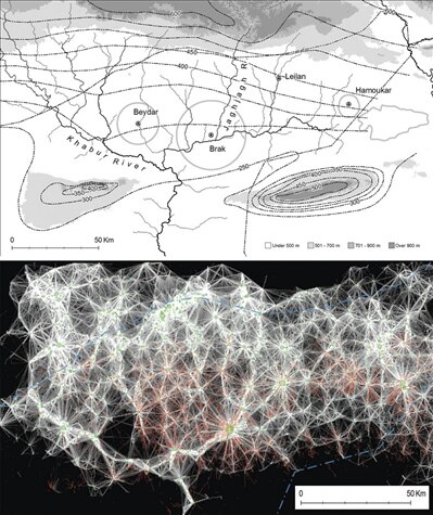
Topographical maps combines with MIT's anaysis show connections between past civilizations (via Proceedings of the National Academy of Sciences of the USA)


Using unique soil signatures and satellite images, MIT researchers have created a new way to study past civilizations. Human activities such as large-scale settlements leave distinctive patterns in the soil. These patterns, called Anthrosols, have fine textures and lighter reflective properties. As a result, these patterns can be seen from satellite images exploiting human migration patterns. These methods can help us prove new and old hypothesis, and learn more about areas in which we have little or restricted access. Currently, computer science researcher Bjoern Menze has created a software program that takes the satellite images and maps the Anthrosol patterns by analyzing the wavelength patterns. Although the software can detect large settlements very well, it currently is not reliable detecting smaller settlements due to the sporadic or less dense wavelengths detected.


You don't have permission to edit metadata of this video.
Edit media
x
image
Upload Preview
image


Now dealing with the present, Google will be adding a new feature to its street view software.  The software will enable viewers to traverse rivers and trails in the Amazon. It works on the same concept as street view using over 50,000 photos together to create a panoramic picture that can be viewed from any direction. The project will allow viewers to learn more about the Amazon from the comfort of their own homes while providing access to areas restricted to the public and was funded by the non-profit organization Amazonas Sustainable Foundation.


image

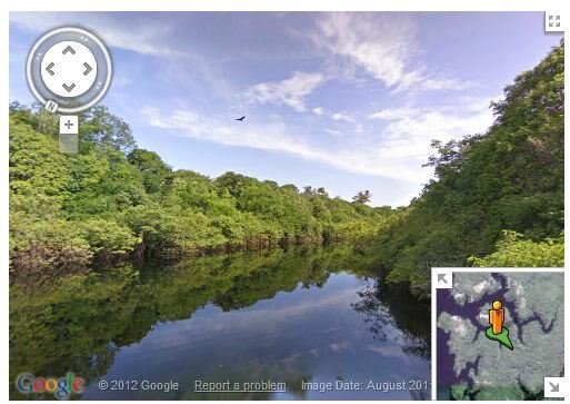
Tibutary of the Rio Negro (via Google)


Sounds like one of the best jobs in the world, taking the Google street view camera through the Amazon.


Using technology can help us learn more about the past, present, and future of our planet Earth. With more easily accessed information, Today's generation has the potential to learn about anything they desire with a few clicks.


Cabe

http://twitter.com/Cabe_e14

  • Sign in to reply
  • DAB
    DAB over 13 years ago

    This is a wonderful idea.

    I hope they expand their data to include all parts of the world.  The benefit to education is emense as you can now let students explore the world with a closer feel for the scenery, the way people live, and their day to day lives.  Essentially a virtual tourism visit via the web.

    I like it.  You can now learn much more about anywhere in the world or any people or societies that they can collect data.


    DAB

    • Cancel
    • Vote Up 0 Vote Down
    • Sign in to reply
    • More
    • Cancel
element14 Community

element14 is the first online community specifically for engineers. Connect with your peers and get expert answers to your questions.

  • Members
  • Learn
  • Technologies
  • Challenges & Projects
  • Products
  • Store
  • About Us
  • Feedback & Support
  • FAQs
  • Terms of Use
  • Privacy Policy
  • Legal and Copyright Notices
  • Sitemap
  • Cookies

An Avnet Company © 2025 Premier Farnell Limited. All Rights Reserved.

Premier Farnell Ltd, registered in England and Wales (no 00876412), registered office: Farnell House, Forge Lane, Leeds LS12 2NE.

ICP 备案号 10220084.

Follow element14

  • X
  • Facebook
  • linkedin
  • YouTube