


The science of tracking and predicting the path of Hurricanes has improved in accuracy over the years but there has been little improvement in the accuracy of determining how intense the storms are going to be. Now, ten years after Hurricane Katrina formed in the Atlantic, construction of NASA's new hurricane-observing satellites is now underway in Texas. The space agency plans to use a constellation of eight micro-satellites to make accurate measurements of ocean surface winds in and near the eye of a storm throughout the lifecycle of tropical cyclones, typhoons and hurricanes.
The Cyclone Global Navigation Satellite System, or CYGNSS, will be the first to probe the inner core of hurricanes in greater detail to better understand their rapid intensification. The mission is scheduled to launch in late 2016 from Cape Canaveral Air Force Station, Florida, aboard a Pegasus XL rocket.
Previously, measuring wind speed over the oceans from space employed a technique called scatterometry. A radar instrument aboard a satellite sent a signal to the ground, and measured the signal strength reflected back to it. Building both sending and receiving capabilities into a single instrument, however, is more expensive than the method being used on CYGNSS, which is being developed by the University of Michigan, whose role includes satellite design and production and science data processing. The CYGNSS satellites will only receive signals broadcast to them from GPS satellites already orbiting the Earth; it will use GPS signals bounced off of ocean surfaces to measure the height of waves and wind speeds. This data will be shared with NOAA and used to help emergency managers make decisions regarding extreme weather planning.
The use of eight satellites will increase the area on Earth that can be measured. The instruments will be deployed separately around the planet, with successive satellites passing over the same region every 12 minutes. As the CYGNSS and GPS constellations move around the Earth, the interaction of the two systems will result in a new image of wind speed over the entire tropics every few hours, compared to every few days for a single satellite.
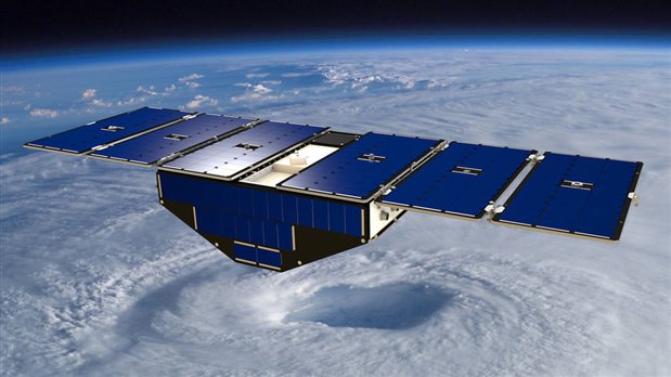
Assembly of the first micro-satellite began Aug. 14, with the other seven to follow in the next few weeks. The body of each satellite measures about 20-x-25-x-11 inches and when fully assembled the satellites will each weigh about 64 pounds. With its solar panels deployed, each micro-satellite will have a wingspan of 5.5 feet.
-

Former Member
-
Cancel
-
Vote Up
0
Vote Down
-
-
Sign in to reply
-
More
-
Cancel
Comment-

Former Member
-
Cancel
-
Vote Up
0
Vote Down
-
-
Sign in to reply
-
More
-
Cancel
Children