


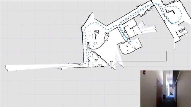
System in operation. The red triangle shows the current location, which the blue is showing where it has been. (via MIT)
In something that looks straight out of a video game, MIT students have fused a light detection and ranging (LIDAR) sensor, barometric sensors, a MicroStrain inertial measurement unit (IMU) and a Microsoft Kinect camera to create a real-time mapping system. Worn, the user needs only walk around in the desired indoor area. Certain to innovate the search and rescue industry.
The prototype unit is called the SLAM (Simultaneous Localization and Mapping) unit and it is portable but requires that the user carry a laptop so all the signal processing can be done on it. Eventually the team hopes to develop the same system in a handheld device. The entire system functions using only the components carried by the user.


(left) Current in carnation of the SLAM device worn by a student (Right) Block diagram of the SLAM sensors and processing (via MIT)
The device works by taking successive snapshots with the LIDAR and the Kinect camera as the IMU detects user movements like walking. It scans over a 270-degree arc and has a 30m range in front of the user. The Kinect’s visual images and depth information are collected and processed. Finally, overlapping all collected data begins to create a 2D digital image that becomes a map on the computer screen. Barometric sensors in the backpack can even detect when the user travels to another floor using stairs or elevators, and this transition begins another map. The user can also use mouse clicks to indicate places of interest.
The fact that this system is meant for human use means that a lot of error correcting software algorithms had to be developed. The IMU keeps track of the users walking and it also provides necessary information to correct distortions in the map that result from tilting of the LIDAR and Kinect units. When the SLAM wearer visits a location again, the Kinect’s images are used to detect this and further corrections to the previous map can be corrected. The system was also made to rightly detect false-loop closures where objects may look the same but are located in a different space. Once complete, maps can be transferred digitally.
The SLAM device is meant to help firefighters, biohazard units etc. safe and informed. Future work on the project aims to miniaturize the system so it can be carried like a mines lantern or over the shoulder. The team also wants to explore how humans can be used alongside robots. The project was funded by the US Air Force and the Office of Naval Research. The SLAM prototype will be discussed at the Intelligent Robots and Systems 2012 Conference in Portugal this October.
Cabe
