element14 Community
element14 Community
    Register Log In
  • Site
  • Search
  • Log In Register
  • Community Hub
    Community Hub
    • What's New on element14
    • Feedback and Support
    • Benefits of Membership
    • Personal Blogs
    • Members Area
    • Achievement Levels
  • Learn
    Learn
    • Ask an Expert
    • eBooks
    • element14 presents
    • Learning Center
    • Tech Spotlight
    • STEM Academy
    • Webinars, Training and Events
    • Learning Groups
  • Technologies
    Technologies
    • 3D Printing
    • FPGA
    • Industrial Automation
    • Internet of Things
    • Power & Energy
    • Sensors
    • Technology Groups
  • Challenges & Projects
    Challenges & Projects
    • Design Challenges
    • element14 presents Projects
    • Project14
    • Arduino Projects
    • Raspberry Pi Projects
    • Project Groups
  • Products
    Products
    • Arduino
    • Avnet Boards Community
    • Dev Tools
    • Manufacturers
    • Multicomp Pro
    • Product Groups
    • Raspberry Pi
    • RoadTests & Reviews
  • Store
    Store
    • Visit Your Store
    • Choose another store...
      • Europe
      •  Austria (German)
      •  Belgium (Dutch, French)
      •  Bulgaria (Bulgarian)
      •  Czech Republic (Czech)
      •  Denmark (Danish)
      •  Estonia (Estonian)
      •  Finland (Finnish)
      •  France (French)
      •  Germany (German)
      •  Hungary (Hungarian)
      •  Ireland
      •  Israel
      •  Italy (Italian)
      •  Latvia (Latvian)
      •  
      •  Lithuania (Lithuanian)
      •  Netherlands (Dutch)
      •  Norway (Norwegian)
      •  Poland (Polish)
      •  Portugal (Portuguese)
      •  Romania (Romanian)
      •  Russia (Russian)
      •  Slovakia (Slovak)
      •  Slovenia (Slovenian)
      •  Spain (Spanish)
      •  Sweden (Swedish)
      •  Switzerland(German, French)
      •  Turkey (Turkish)
      •  United Kingdom
      • Asia Pacific
      •  Australia
      •  China
      •  Hong Kong
      •  India
      •  Korea (Korean)
      •  Malaysia
      •  New Zealand
      •  Philippines
      •  Singapore
      •  Taiwan
      •  Thailand (Thai)
      • Americas
      •  Brazil (Portuguese)
      •  Canada
      •  Mexico (Spanish)
      •  United States
      Can't find the country/region you're looking for? Visit our export site or find a local distributor.
  • Translate
  • Profile
  • Settings
Personal Blogs
  • Community Hub
  • More
Personal Blogs
NexGen Flight Simuator Flight Simulator 101 or back to college - part 8: The Earth and its mathematics.
  • Blog
  • Documents
  • Mentions
  • Sub-Groups
  • Tags
  • More
  • Cancel
  • New
  • Share
  • More
  • Cancel
Group Actions
  • Group RSS
  • More
  • Cancel
Engagement
  • Author Author: phoenixcomm
  • Date Created: 19 May 2016 8:42 PM Date Created
  • Views 1289 views
  • Likes 7 likes
  • Comments 19 comments
  • flight_simulator
  • nexgen
  • Math
  • feature_tutorial
  • simulator
Related
Recommended

Flight Simulator 101 or back to college - part 8: The Earth and its mathematics.

phoenixcomm
phoenixcomm
19 May 2016

Why did I say: "The Earth and its mathematics", because all of the math used in flight, or navigational simulators or SPS(games), are based on the Earth and it's dimensions ~ though the NAV simulation represents but a small fraction of the math used in flight simulators.

image
figure 1

➀ Having nothing to do with the definition of Nautical Miles (“nMile”), from ???, we know that at the Earth's equatorial circumference is 21,604.2 [or 21,639 or ???] nMile. From High School Math and Geography, we know that a great circle is defined as any plane which passes through the center of the Earth (if the Earth were a sphere) [see figure 1]. We also know that the shortest distance between any two points of the surface of a spherical Earth must be a great circle route. Now, if the Earth were only a sphere.

➁ From High School Math, we know that a circle has 360ℴ (degrees), So if we divide 21604.2 by 360 or 21604.2n.m. /360 = 60.011 ≈ 60n.m at the equator. Remember that the closer you get to the poles , the longitudinal degrees converge, therefore, the change must be accounted for by using the cosine of the latitude.


The following inverse pair of formulas describe the spherical relationships between the difference in distance (Δdist) along a parallel of latitude (lat) corresponding to a difference in longitude (Δlong), and vice-versa.  (The formulas are simply stated here without explanation, but a full explanation of their derivation can be found in the book ‘Astro Navigation Demystified’ ).
  • Δdist = Δlong x Cos(lat), and inversely
  • Δlong = Δdist ÷ Cos(lat)
image
figure 2


The traditional, historic definition of 1 nMile is 1 minute [= 1/60 degree] of latitude along the Greenwich meridian - thus, by this definition, 60 nMile = 1 degree of latitude; the current standard SI definition: 1 nMile is 1852 meters.

➂ Engineers and Cartographers do use degrees, as anyone who has looked at a map will recognize: latitude and longitude are denoted in degrees, minutes, and seconds; but, we will use radians for angle measurement So what is a radian?

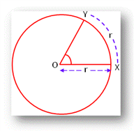
Looking at a circle[figure 2], we get the definition of a Radian as the angle subtended at the center of the circle by an arc of the circumference of the circle whose length is equal to the radius of the circle.

∠XOY = 1 radian, where r = OX = OY = XY

Again from High School Math, we know the total circumference of a circle of radius, r, is 2 ∙ π ∙ r; thus, there are 2 ∙ π Radians in the circumference of a circle.

Since 2 ∙ π radians is equivalent to 360 degrees, a full circle, the relationships are :

  • 1 radian  = 180 / π degrees, and inversely
  • 1 degree = π / 180 radians.

A radian can be written in a variety of ways: 1c, 2 radians, 3r, 4R, 5 ㎭.

The defined and some (approximate) derived relationships between degrees and radians:

360º = 2 ∙ π ㎭

1º = .01745 ㎭

1 ㎭ = 57.2957º


Keep Tuned In, More To Come

~~ Cris  image  

19MAY2016

PS. Thank you, Paul, for all your help!


24MAY2016 fixed title typo it sb its

  • Sign in to reply

Top Comments

  • D_Hersey
    D_Hersey over 9 years ago +1
    Many more writers describe what a radian is than describe the motivation behind using it 360 is convenient when we seek to divide the circle by prime factors of 360, or products thereof In a universe of…
  • phoenixcomm
    phoenixcomm over 9 years ago in reply to balearicdynamics +1
    Hi Enrico, whats up?? please check out http://www.phoenixcomm.net/~phnx2000/sim/demo/index.shtml you can launch it by clicking at the top. This was written in Perl about 8 or 10 years ago. Almost no documentation…
  • DAB
    DAB over 9 years ago +1
    Another post that brings back memories. I remember a lot of meetings during an integrated navigation system design where all of these ghastly details were discussed at great length. Made me want to be…
  • phoenixcomm
    phoenixcomm over 8 years ago in reply to jw0752

    Ok, what would you like for dessert?? My conversion routines, that I wrote. or maybe something else.. 

    • Cancel
    • Vote Up 0 Vote Down
    • Sign in to reply
    • More
    • Cancel
  • jw0752
    jw0752 over 8 years ago in reply to phoenixcomm

    Hi Cris,

    I just remember reading  "Keep Tuned In, More To Come".


    You can't just throw some delicious math and physics at us and not expect us to want dessert.


    I will keep tuned in though just in case you want to exercise your thoughts on us again.


    John

    • Cancel
    • Vote Up +1 Vote Down
    • Sign in to reply
    • More
    • Cancel
  • phoenixcomm
    phoenixcomm over 8 years ago in reply to jw0752

    John,

    I was not really thinking about an installment. I wrote this as an exercise, for myself, as I have a lot of problems with my memory as I am taking gabapentin / Lyrica for pain in my feet. What would you suggest for a follow on? Navigation and or conversion formulas and functions  that I used to put my demo together in Perl, which I am converting to C. There will be an FAA database online (MySQL) for this and Radio Nav including the radios. When the simulator is flying it will be flying over Google Earth. Currently the system does not have "free flight" which I hope to have sooner than later.

    Cris

    • Cancel
    • Vote Up 0 Vote Down
    • Sign in to reply
    • More
    • Cancel
  • DAB
    DAB over 9 years ago in reply to phoenixcomm

    We have a fair number of cattle on free range at the ranch, I am sure they can come up with your deposit.


    DAB

    image

    • Cancel
    • Vote Up +1 Vote Down
    • Sign in to reply
    • More
    • Cancel
  • mcb1
    mcb1 over 9 years ago

    Looks like a very interesting subject.

    I always measure my degrees using Celcius ... image


    Never did get the angular thing, but it was a step upwards curve when I first played with Accelerometers.


    Mark

    • Cancel
    • Vote Up +1 Vote Down
    • Sign in to reply
    • More
    • Cancel
>
element14 Community

element14 is the first online community specifically for engineers. Connect with your peers and get expert answers to your questions.

  • Members
  • Learn
  • Technologies
  • Challenges & Projects
  • Products
  • Store
  • About Us
  • Feedback & Support
  • FAQs
  • Terms of Use
  • Privacy Policy
  • Legal and Copyright Notices
  • Sitemap
  • Cookies

An Avnet Company © 2025 Premier Farnell Limited. All Rights Reserved.

Premier Farnell Ltd, registered in England and Wales (no 00876412), registered office: Farnell House, Forge Lane, Leeds LS12 2NE.

ICP 备案号 10220084.

Follow element14

  • X
  • Facebook
  • linkedin
  • YouTube