


Researchers at MIT have employed a fleet of drones with the same system found in self-driving to be more effective in search and rescue missions. This new system doesn’t rely on GPS, which is often non-existent in forested areas. (Photo & video via MIT)
Drones are being used for more things aside from delivering your Amazon package. They’ve been employed in search and rescues missions proving to be effective tools. Unfortunately, this doesn’t hold up when conducting a search and rescue mission in a densely packed forest. Due to tree coverage, GPS signals are unreliable or nonexistent in these environments. But a team of MIT researchers thinks they may have found a solution using the same technology found in self-driving cars.
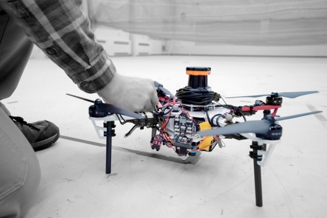
In a recently published paper, researchers talk about an autonomous system for a fleet of drones to search in forest environments. Instead of relying on GPS, they would use only onboard computation and wireless communication. For testing, researchers placed a LIDAR system, which creates a 2D scan of surrounding obstacles by shooting laser beams and measuring the reflected pulses. This helps the system identify trees.
Each drone is also equipped with laser-range finders for position estimation, localization, and path planning. As it flies, it creates a 3D map of the area so it can determine where it has already searched. Individual maps from the drones are then merged into a global 3D map at an off-board ground station monitored by human rescue workers.
“Essentially, we’re replacing humans with a fleet of drones to make the search part of the search-and-rescue process more efficient,” says first author Yulun Tian, a graduate student in the Department of Aeronautics and Astronautics (AeroAstro).
Multiple drones were tested in simulations of randomly generated forest while two drones were tested in a forested area within NASA’s Langley Research Center. The results proved to be promising with each drone mapping a 20-square meter area in about two to five minutes. Both also succeeded in different metrics, like overall speed and time to finish the mission, detecting forest features, and merging the maps accurately.
The system sounds promising and could greatly improve the rescue mission, but more work needs to be done. The team is looking at adding an object recognition system in order to identify lost hikers. Ideally, the drone would tag the hiker’s location on the global map allowing human workers to plan the rescue mission. Still, the system has the potential to help rescue workers find people without relying on big groups, and it could speed up the whole process.
Have a story tip? Message me at: cabe(at)element14(dot)com
