


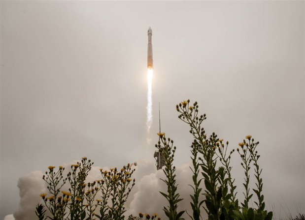
On September 27th, NASA’s Landsat 9 spacecraft launched to continue monitoring the Earth’s features. (Image Credit: NASA/Bill Ingalls)
NASA successfully launched its latest Earth-orbiting satellite into space! On September 27th, a United Launch Alliance (ULA) Atlas V rocket lifted off with NASA’s Landsat 9 from Vandenberg Space Force Base in California at 2:12 p.m. EDT. The spacecraft separated from the rocket approximately 82 minutes after liftoff. Landsat 9’s objective is to continue the earth-monitoring Landsat program.
“NASA uses the unique assets of our own unprecedented fleet, as well as the instruments of other nations, to study our own planet and its climate systems,” said NASA Administrator Bill Nelson. “With a 50-year data bank to build on, Landsat 9 will take this historic and invaluable global program to the next level. We look forward to working with our partners at the US Geological Survey and the Department of the Interior again on Landsat next because we never stop advancing our work to understand our planet.”
Although NASA launched Landsat 9, the United States Geological Survey operates the satellite and processes its data. The $750 million mission, the ninth in this program, involves Landsat 9 replacing Landsat 7, which started orbiting the Earth in 1999. The newly launched satellite will work with Landsat 8 to image the Earth once every eight days. Both satellites monitor forest cover, urban sprawl, retreating glaciers, water quality, coral reef habitat health, and other phenomena.
“Landsat 9 will be our new eyes in the sky when it comes to observing our changing planet,” said Thomas Zurbuchen, associate administrator for science at NASA. “Working in tandem with the other Landsat satellites, as well as our European Space Agency partners who operate the Sentinel-2 satellites, we are getting a more comprehensive look at Earth than ever before. With these satellites working together in orbit, we’ll have observations of any given place on our planet every two days. This is incredibly important for tracking things like crop growth and helping decision-makers monitor the overall health of Earth and its natural resources.”
Later on, Landsat 9 will lock in an orbit, taking it 438 miles above the planet’s poles. The spacecraft features the Operational Land Imager 2 (OLI-2), along with the Thermal Infrared Sensor 2 (TIRS-2) that detects minute changes in rivers, lakes, and forests. These operate by analyzing light reflected off the planet’s surface in multiple wavelengths. More specifically, it can image four visible spectral bands, one near-infrared spectral band, three shortwave infrared spectral bands at 30m spatial resolution, one panchromatic band at 15m spatial resolution, and two thermal bands at 100m spatial resolution. Scientists can then use these images to measure water quality and high, thin clouds.
During its orbit, the satellite’s instruments capture high-resolution images across a 115-mile swath. One pixel represents 98 feet across, similar to a baseball infield’s size. This allows resource managers to identify many crop fields in the US.
Four small CubeSats also joined the Landsat 9 launch into space to perform various science observations, such as measuring the solar wind and ultraviolet light from stars. The Atlas V has another mission coming up on October 16th: launching the Lucy spacecraft, which will head to the asteroid belt. Its task is to study several Trojan asteroids to help researchers better understand a planet's formation process.
Have a story tip? Message me at: http://twitter.com/Cabe_Atwell