


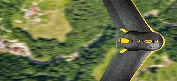
SenseFly’s eBee drone, mapping surfaces? The future... (via SenseFly)
Drones have proven themselves highly proficient when it comes to combat operations and surveillance platforms over the last few decades, but they have since proven themselves in other fields featuring less death. Fleets of drones (four or more) have been put to use in S&R (search and rescue) operations with very surprising results (University of Lancaster’s AeroSee program) and now a new fleet has been put into action for the purpose of mapping large areas and landmarks in unprecedented detail. UAV manufacturer SenseFly recently teamed up with aerial imaging company Pix4D to map one of the highest peaks in the Pennine Alps: the Matterhorn.
Standing at 14,690 feet, the famous mountaineering giant was tough to map in high detail by conventional methods, so the pair decided to do it from the air remotely. SenseFly provided the drone fleet, consisting of three eBee drones capable of covering an area of 10-square miles in a 45-minute flight, more than enough time to map the mountain. The drones are powered by a lithium-polymer battery, have detachable wings for easy storage, are fully autonomous and can even land itself. Affixed to the foam airframe is a 16MP camera capable of taking imagery down to 3cm-pixel resolutions in order to create maps and topography models in great detail. The drones were programmed with waypoints that covered the entire mountain and were then launched (thrown actually) off the peak to begin their mapping decent. It took no more than six hours to garner the imagery (one picture every 20cm/over 2000 images) needed for a complete map, which was then processed and stitched together by Pix4D using advanced modeling software in great detail. With the negative press about drones in the news, it’s nice to see others using them for more than just surgical strikes.
C
See more news at:
