


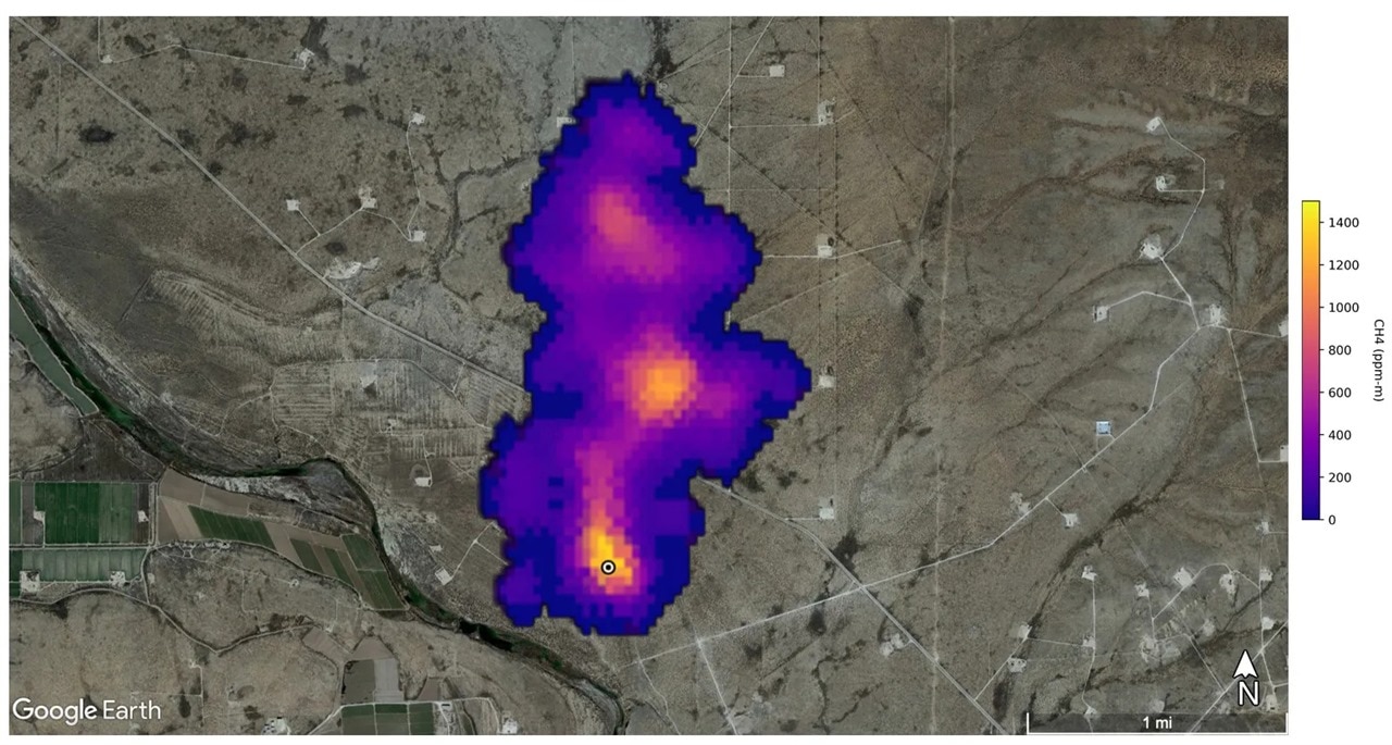
NASA’s EMIT sensor detected this 2-mile-long methane plume in New Mexico. (Image Credit: NASA/JPL-Caltech)
In 2023, Kayrros, an environmental intelligence company, used satellite data to determine exactly where 1,300 super-emitters of methane plumes are sourced worldwide. As a result, the company discovered all those leaks came from pipelines, gas wells, landfill sites, and coal mines in Russia, India, Australia, the US, and Turkmenistan. Identifying the methane leaks can help put humanity on the right track toward solving the issue.
The data revealed that Turkmenistan became the largest methane emitter from oil and gas, releasing 333 tons per hour (peak) in August from a Cheleken Peninsula-based facility. This rate Is similar to a vehicle traveling 38,000 miles, emitting the same amount of greenhouse gas emissions.
Other places like Kazakhstan leaked 21 – 56 tons of methane per hour from a drilling well, starting from June to November. Shanxi, China, also saw a coal plant release 181 tons per hour (peak) in February. Meanwhile, a waste site in Bangladesh emitted a peak amount of 822 tons of methane per hour in April.
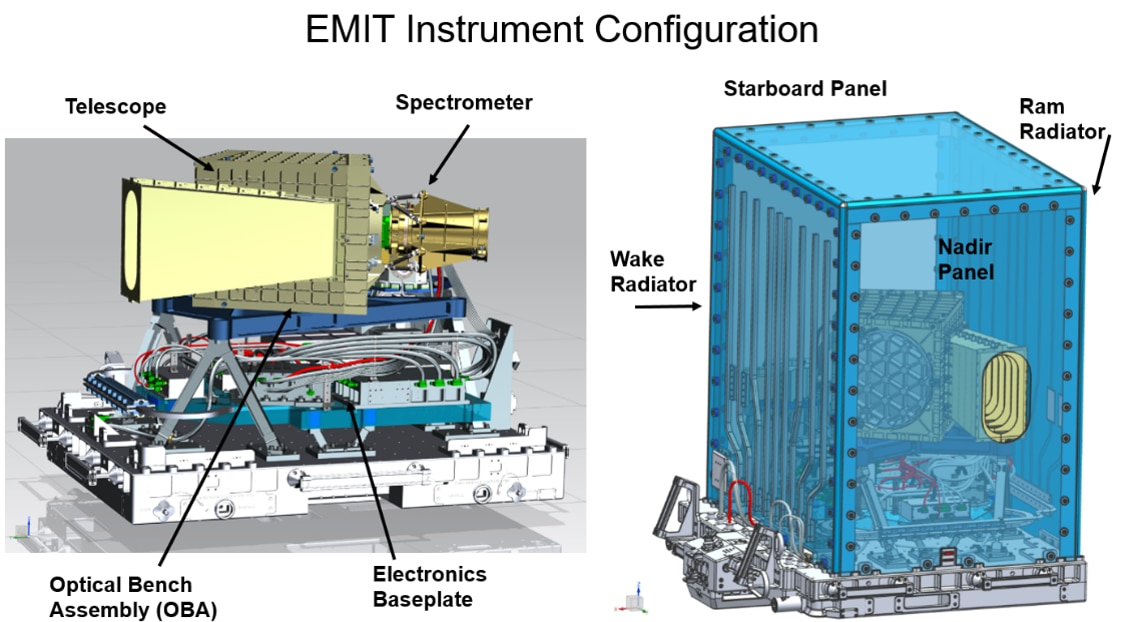
The imaging spectrometer and telescope in NASA’s EMIT instrument. (Image Credit: NASA)
Kayrros uses the Earth Surface Mineral Dust Source Investigation (EMIT) instrument, a NASA-built hyperspectral sensor on the ISS, to obtain data on the Earth’s methane plumes. It has a high throughput F/1.8 Dyson imaging spectrometer and an advanced two-mirror telescope. The Dyson telescope takes in sunlight, focusing it on the spectrometer slit and moving it through the calcium fluoride crystal refractive element to the grating. That concave grating features a structured blaze for optimizing the diffraction efficiency across the full spectral range. Once dispersed in the spectrum, the light moves through the CaF2 block before reaching the order sorting filter and detector area array (sensitive from the visible to short wavelength infrared of the electromagnetic spectrum). The detector array’s columns record the spectrum for a 1240 cross-track EMIT swath sample. All the imaging spectrometer image cubes undergo calibration to spectral radiance before being corrected and analyzed to find out their mineral composition.
The Imaging spectrum obtains 50-mile-by-50-mile images of the earth’s surface at 60m resolution. It also comes with a 500kg/hour methane threshold.
The company also relies on the ESA-developed Sentinel-5P satellite for methane monitoring. It has a 108° wide swath, allowing the instrument to provide a surface coverage of radiance and reflectance measurements. This satellite features a TROPOMI (TROPOspheric Monitoring Instrument) that has a 7x7km2 spatial sampling and four spectrometers. The spectrometers are split into two bands: UV (2), VIS (2), NIR (2), and SWIR (2). The radiometric accuracy is 1.6% (SWIR) to 1.9% (UV) of the earth spectral reflectance. Additionally, this satellite has a 10 tons/hour methane threshold.
The Environmental Protection Agency says methane changes the Earth’s temperature since it lingers in the atmosphere for ten years. It may not seem like a long time, but that presence has a significant impact over that period. We can see a positive impact if the methane leaks are addressed. MIT has already set foot in this area, creating techniques to capture methane in the atmosphere.
Recently, the United States introduced methane monitoring and repair policies for fossil fuel companies. These could remove 58 million tons of methane emissions between 2024 and 2038. To date, 150 countries signed the Global Methane Pledge to slash methane releases by 30% by 2030. This may drop the global average temperature by 0.2C while preventing 250,000 deaths due to heat exposure.
Have a story tip? Message me at: http://twitter.com/Cabe_Atwell
