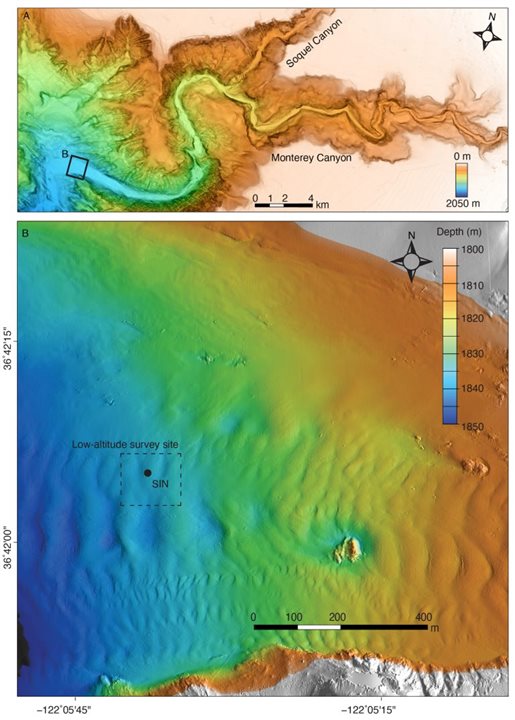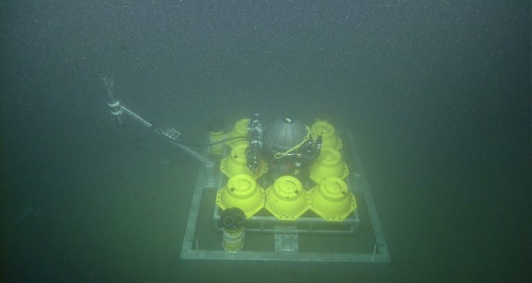
The MBARI team conducted high-res surveys of the Monterey Canyon floor, 50km from the canyon head. They also deployed a Seafloor Instrument Node to observe currents and how they affect the site. (Image Credit: Monica Wolfson-Schwehr © 2023 MBARI)
Researchers at MBARI used remotely operated vehicles equipped with the low altitude survey system (LASS) to survey and map the seabed of the Monterey Canyon in precise detail. All the centimeter-scale surveys they conducted over 18 months allowed them to gain better insights into the submarine canyon sculpting processes. Additionally, their study could help them better understand how submarine canyons could be linked to local tsunamis or risks to underwater telecommunication infrastructures.
“Thanks to advanced MBARI technology, we’ve now mapped parts of Monterey Canyon in remarkable detail. Repeated mapping surveys have given us a valuable new perspective to study the processes that sculpt the canyon. This is vital context for understanding not only life on the ocean floor but also how the underwater infrastructure that we depend on may be vulnerable to underwater landslides,” explained Monica Wolfson-Schwehr, previously a postdoctoral fellow at MBARI and lead author of this study.
The LASS combines five-centimeter resolution multibeam (sonar) bathymetry, one-centimeter resolution lidar (laser) bathymetry, and two-millimeter resolution stereo photography. The lasers and sonar pulse to the bottom as the vessel travels three meters above the floor. While the sonar records rocks, mud, and other structures on the seabed, the lasers record 3D objects beneath the vessel, such as live animals with soft tissue. These high-res images are then draped onto the bathymetry data, producing a realistic seafloor image. “These incredibly detailed surveys can quantify the impact of the geological, geochemical, and biological processes that modify the seafloor at fine scales.”
The team’s study site is located 31 miles from the Monterey Canyon head at a depth of 6,037 feet, where they spent 18 months conducting four surveys. Combining repeated surveys of the canyon floor with water current monitoring and sediment sampling gave the researchers a better glimpse of the Monterey Canyon’s activity. They also placed a Seafloor Instrument Node (SIN) on the floor, and the upward-looking acoustic Doppler current profilers recorded current flow.

The Seafloor Instrument Node measured environmentalx conditions of the Monterey Canyon floor, 1,840 meters deep. (Image Credit: Monica Wolfson-Schwehr © 2015 MBARI)
The SIN’s sensors detected three turbidity currents flowing at 0.9 to 3.3 meters per second. These current types that moved at a similar speed in the upper Monterey Canyon created rapid bedform migration. But the LASS surveys determined those events didn’t lead to any note-worthy changes on the canyon floor’s seabed.
“Studying sediment samples from the lower canyon revealed the relatively coarse nature of the seafloor at this location. Coarse sediment suggested that the turbidity currents in the lower canyon lacked the fast, dense layers near the base of the flow that are characteristic of turbidity currents recorded farther up-canyon. The large boulders that underlie the bedforms in the lower part of the canyon may have also accounted for the negligible changes to the seabed that the team observed.”
Tides also oscillate up and down a submarine canyon. The SIN sensors recorded the tides’ rhythm on the canyon floor. Standard ship-based instruments can’t detect the tiny amount of sediment being moved by internal tides. But the LASS sensor allows researchers to measure any canyon floor structure changes that occurred from tidal currents. They discovered the tides’ ebb and flow sculpted the tiny meter-sized scours and centimeter-sized textures on the canyon floor’s seabed.
“With sonar, we see the aftermath of large, catastrophic events but miss the small, minute changes that happen every day,” said Wolfson-Schwehr. “As technology advances and we can map at finer and finer resolutions, we can observe a new level of complexity in the seabed. We don’t realize how much of the picture we’ve been missing.”
“Geology has always been a historical science that looks at seafloor deposits laid down a long time ago. MBARI technology is allowing us to study submarine geomorphology at a scale we haven’t been able to before. Repeated high-resolution surveys are providing a real-time dimension for understanding seafloor changes,” added Charlie Paull, a senior scientist at MBARI and a coauthor of this study.
Have a story tip? Message me at: http://twitter.com/Cabe_Atwell
