element14 Community
element14 Community
    Register Log In
  • Site
  • Search
  • Log In Register
  • About Us
  • Community Hub
    Community Hub
    • What's New on element14
    • Feedback and Support
    • Benefits of Membership
    • Personal Blogs
    • Members Area
    • Achievement Levels
  • Learn
    Learn
    • Ask an Expert
    • eBooks
    • element14 presents
    • Learning Center
    • Tech Spotlight
    • STEM Academy
    • Webinars, Training and Events
    • Learning Groups
  • Technologies
    Technologies
    • 3D Printing
    • FPGA
    • Industrial Automation
    • Internet of Things
    • Power & Energy
    • Sensors
    • Technology Groups
  • Challenges & Projects
    Challenges & Projects
    • Design Challenges
    • element14 presents Projects
    • Project14
    • Arduino Projects
    • Raspberry Pi Projects
    • Project Groups
  • Products
    Products
    • Arduino
    • Avnet Boards Community
    • Dev Tools
    • Manufacturers
    • Multicomp Pro
    • Product Groups
    • Raspberry Pi
    • RoadTests & Reviews
  • Store
    Store
    • Visit Your Store
    • Choose another store...
      • Europe
      •  Austria (German)
      •  Belgium (Dutch, French)
      •  Bulgaria (Bulgarian)
      •  Czech Republic (Czech)
      •  Denmark (Danish)
      •  Estonia (Estonian)
      •  Finland (Finnish)
      •  France (French)
      •  Germany (German)
      •  Hungary (Hungarian)
      •  Ireland
      •  Israel
      •  Italy (Italian)
      •  Latvia (Latvian)
      •  
      •  Lithuania (Lithuanian)
      •  Netherlands (Dutch)
      •  Norway (Norwegian)
      •  Poland (Polish)
      •  Portugal (Portuguese)
      •  Romania (Romanian)
      •  Russia (Russian)
      •  Slovakia (Slovak)
      •  Slovenia (Slovenian)
      •  Spain (Spanish)
      •  Sweden (Swedish)
      •  Switzerland(German, French)
      •  Turkey (Turkish)
      •  United Kingdom
      • Asia Pacific
      •  Australia
      •  China
      •  Hong Kong
      •  India
      •  Korea (Korean)
      •  Malaysia
      •  New Zealand
      •  Philippines
      •  Singapore
      •  Taiwan
      •  Thailand (Thai)
      • Americas
      •  Brazil (Portuguese)
      •  Canada
      •  Mexico (Spanish)
      •  United States
      Can't find the country/region you're looking for? Visit our export site or find a local distributor.
  • Translate
  • Profile
  • Settings
Sensors
  • Technologies
  • More
Sensors
Blog NASA Used Optical Satellite Imagery to See the Long-Term Impact of the Megatsunami That Struck in 1958
  • Blog
  • Forum
  • Documents
  • Quiz
  • Events
  • Polls
  • Members
  • Mentions
  • Sub-Groups
  • Tags
  • More
  • Cancel
  • New
Join Sensors to participate - click to join for free!
  • Share
  • More
  • Cancel
Group Actions
  • Group RSS
  • More
  • Cancel
Engagement
  • Author Author: Catwell
  • Date Created: 24 Jul 2025 11:00 AM Date Created
  • Views 2355 views
  • Likes 4 likes
  • Comments 0 comments
  • research
  • landsat 8
  • megatsunami
  • landsat 9
  • nasa
  • cabeatwell
  • satellite
  • GIS
  • sensor
Related
Recommended

NASA Used Optical Satellite Imagery to See the Long-Term Impact of the Megatsunami That Struck in 1958

Catwell
Catwell
24 Jul 2025

image

The largest tsunami ever recorded struck Lituya Bay in 1958. (Image Credit: NASA Earth Observatory)

In 1958, a huge landslide caused 90 million tons of rock to slam into Alaska’s Lituya Bay. This impact produced a tsunami with a wave height of over 500 meters, the largest tsunami wave recorded to date. The event’s effects were so profound that it changed the landscape. With NASA’s satellite technology, we can see the changes from space today.  

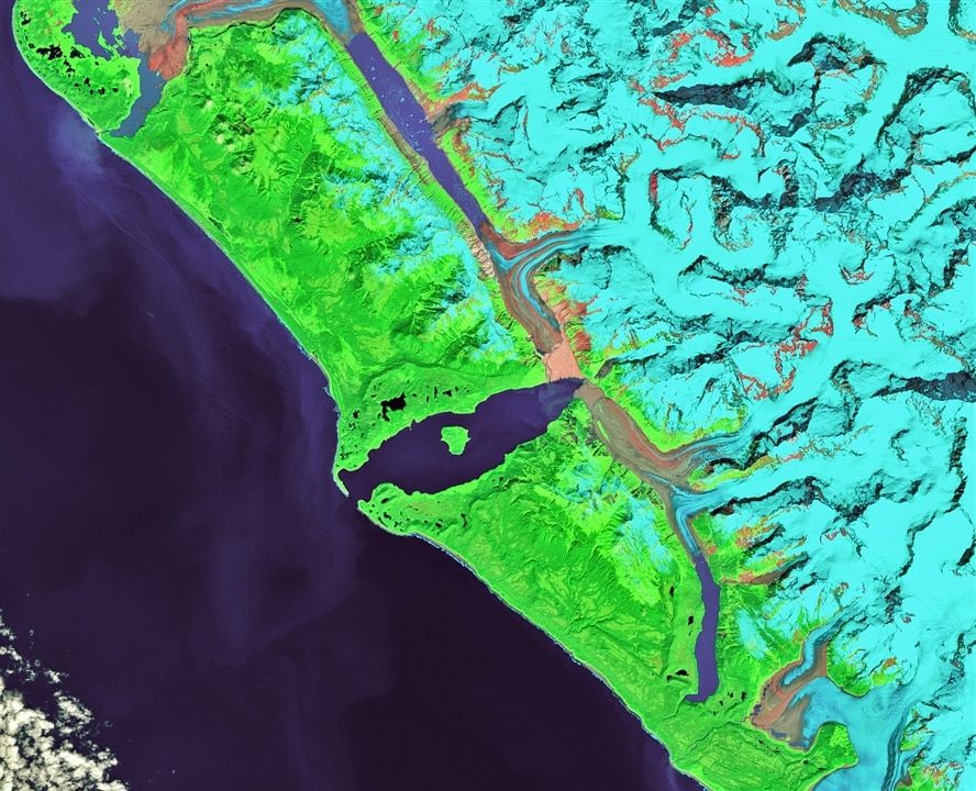
NASA and other agencies used satellite technology to observe the long-term impact of this massive tsunami. It may have lasted a few minutes, but we can still see the effects on the landscape more than 60 years later, thanks to high-resolution optical imaging from satellites like Landsat.

The trimline, a distinct boundary marking the area where the tsunami scoured away vegetation and soil from the hillsides around the bay, remains visible. This trimline appears in false color Landsat imagery (Landsat 8, bands 7-5-3) as a light-colored band along the shore, where younger forests grew, contrasting with the darker green undisturbed forest further inland. NASA’s Landsat 8 and 9, both equipped with the Operational Land Imager (OLI), use visible and near-infrared spectral bands at 30-meter resolution to capture the differences in vegetation recovery.

By analyzing these satellite images, researchers can confirm that the damage from the megatsunami is discernible today. NASA also uses geographic information systems (GIS) and remote sensing software like QGIS and ENVI to layer and interpret the images. This results in a full, clear picture of how a major tsunami event forever altered a stretch of the Alaskan coast.

Now, if they could only use that data to make a visual simulation of the event. Tell me you wouldn’t want to see that…

Have a story tip? Message me at: http://twitter.com/Cabe_Atwell

  • Sign in to reply
element14 Community

element14 is the first online community specifically for engineers. Connect with your peers and get expert answers to your questions.

  • Members
  • Learn
  • Technologies
  • Challenges & Projects
  • Products
  • Store
  • About Us
  • Feedback & Support
  • FAQs
  • Terms of Use
  • Privacy Policy
  • Legal and Copyright Notices
  • Sitemap
  • Cookies

An Avnet Company © 2025 Premier Farnell Limited. All Rights Reserved.

Premier Farnell Ltd, registered in England and Wales (no 00876412), registered office: Farnell House, Forge Lane, Leeds LS12 2NE.

ICP 备案号 10220084.

Follow element14

  • X
  • Facebook
  • linkedin
  • YouTube