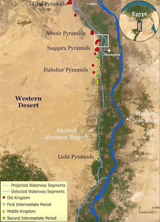
This map displays the ancient river branch along with the pyramids. (Image Credit: Eman Ghoneim et al.)
Over 4,000 years ago, Egypt's 31 pyramids and the Giza complex were built, and how it happened has always remained a big mystery. But the University of North Carolina scientists recently uncovered an ancient, hidden branch of the River Nile along the pyramid complex. They believe it may have been used to transport the materials, like stone blocks, for construction. The paper states the river branch was likely active while the pyramids were being built.
The river branch, called Ahramat, was mapped by the team using radar satellite imagery. With this method, they penetrated the sand surface, exposing unknown buried channels, and generated images of hidden features, like buried rivers and ancient structures. They also used geophysical surveys and sediment coring to verify the river branch’s existence.
They discovered the Ahramat branch was nine miles long and 656-2,296 feet wide. Such a finding potentially explains the large concentration of pyramids between Gaza and Lisht. Rather than humans, ancient Egyptians possibly relied on the river’s energy to deliver the stone blocks.

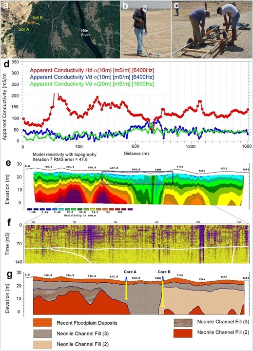
Geophysical survey shows the Ahramat River branch course. (Image Credit: Eman Ghoneim et al.)
The team used the ESA’s Sentinel-1 data, a radar satellite constellation with a C-band synthetic aperture radar (SAR) sensor operating at 5.405 GHz. Sentinel-1 SAR imagery was captured in a descending orbit with an interferometric wide swath mode (IW) at ground resolutions of 5m x 20m and VV + VH dual polarizations. It also has an estimated penetration depth of 50cm in dry, sandy-lose soil. The team used ENVI 5.7 SARscape software to process the radar imagery. SAR processing sequences feature geo-coded, orthorectified, terrain-corrected, noise-free, radiometrically calibrated, and normalized Sentintel-1 images with a 12.5m pixel size.
In addition, Ground Penetrating Radar (GPR) and Electromagnetic Tomography (EMT) mapped subsurface fluvial features and verified the satellite remote sensing discoveries. GPR effectively detects changes in dielectric constant properties of sediment layers, and “its signal responses can be directly related to changes in relative porosity, material composition, and moisture content.” Thus, GPR helps to identify transitional boundaries in subsurface layers.
GPR and EMT, with a 1.2km length, measured a geophysical profile. This survey was performed with a 35MHz central frequency antenna and a 5cm trigger interval. They conducted the EMT survey via the multi-frequency terrain conductivity (EM-34-3) measuring system. Then, a deep soil driller verified the remote sensing and topological data by collecting two sediment cores with 20m and 13m depths. Tanta University performed sieving and organic analysis on those samples to collect grain size data for texture and total organic carbon. In soil texture analysis, medium to coarse sediments, like sands, are found in river channels. Meanwhile, loamy sand and sandy loam deposits are indicative of levees and crevasse splays. Fine texture deposits like silty loams, silty clay loam, and clay deposits represent distal parts of the river floodplain.
Have a story tip? Message me at: http://twitter.com/Cabe_Atwell

-

DAB
-
Cancel
-
Vote Up
0
Vote Down
-
-
Sign in to reply
-
More
-
Cancel
-

Catwell
in reply to DAB
-
Cancel
-
Vote Up
0
Vote Down
-
-
Sign in to reply
-
More
-
Cancel
Comment-

Catwell
in reply to DAB
-
Cancel
-
Vote Up
0
Vote Down
-
-
Sign in to reply
-
More
-
Cancel
Children