element14 Community
element14 Community
    Register Log In
  • Site
  • Search
  • Log In Register
  • Community Hub
    Community Hub
    • What's New on element14
    • Feedback and Support
    • Benefits of Membership
    • Personal Blogs
    • Members Area
    • Achievement Levels
  • Learn
    Learn
    • Ask an Expert
    • eBooks
    • element14 presents
    • Learning Center
    • Tech Spotlight
    • STEM Academy
    • Webinars, Training and Events
    • Learning Groups
  • Technologies
    Technologies
    • 3D Printing
    • FPGA
    • Industrial Automation
    • Internet of Things
    • Power & Energy
    • Sensors
    • Technology Groups
  • Challenges & Projects
    Challenges & Projects
    • Design Challenges
    • element14 presents Projects
    • Project14
    • Arduino Projects
    • Raspberry Pi Projects
    • Project Groups
  • Products
    Products
    • Arduino
    • Avnet Boards Community
    • Dev Tools
    • Manufacturers
    • Multicomp Pro
    • Product Groups
    • Raspberry Pi
    • RoadTests & Reviews
  • Store
    Store
    • Visit Your Store
    • Choose another store...
      • Europe
      •  Austria (German)
      •  Belgium (Dutch, French)
      •  Bulgaria (Bulgarian)
      •  Czech Republic (Czech)
      •  Denmark (Danish)
      •  Estonia (Estonian)
      •  Finland (Finnish)
      •  France (French)
      •  Germany (German)
      •  Hungary (Hungarian)
      •  Ireland
      •  Israel
      •  Italy (Italian)
      •  Latvia (Latvian)
      •  
      •  Lithuania (Lithuanian)
      •  Netherlands (Dutch)
      •  Norway (Norwegian)
      •  Poland (Polish)
      •  Portugal (Portuguese)
      •  Romania (Romanian)
      •  Russia (Russian)
      •  Slovakia (Slovak)
      •  Slovenia (Slovenian)
      •  Spain (Spanish)
      •  Sweden (Swedish)
      •  Switzerland(German, French)
      •  Turkey (Turkish)
      •  United Kingdom
      • Asia Pacific
      •  Australia
      •  China
      •  Hong Kong
      •  India
      •  Korea (Korean)
      •  Malaysia
      •  New Zealand
      •  Philippines
      •  Singapore
      •  Taiwan
      •  Thailand (Thai)
      • Americas
      •  Brazil (Portuguese)
      •  Canada
      •  Mexico (Spanish)
      •  United States
      Can't find the country/region you're looking for? Visit our export site or find a local distributor.
  • Translate
  • Profile
  • Settings
Sensors
  • Technologies
  • More
Sensors
Blog Robot Storm Chasers Deploy Globally
  • Blog
  • Forum
  • Documents
  • Quiz
  • Events
  • Polls
  • Members
  • Mentions
  • Sub-Groups
  • Tags
  • More
  • Cancel
  • New
Join Sensors to participate - click to join for free!
  • Share
  • More
  • Cancel
Group Actions
  • Group RSS
  • More
  • Cancel
Engagement
  • Author Author: Catwell
  • Date Created: 27 Sep 2023 7:02 PM Date Created
  • Views 505 views
  • Likes 5 likes
  • Comments 0 comments
  • research
  • nature
  • sensors
  • hmi
  • robotics
  • robot
  • weather
  • storm chasing
  • cabeatwell
  • earth
  • innovation
Related
Recommended

Robot Storm Chasers Deploy Globally

Catwell
Catwell
27 Sep 2023

image

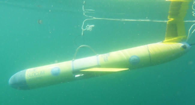
Water gliders are often deployed underwater to help study a hurricane. (Image Credit: University of Georgia Skidaway Institute of Oceanography)

Weather robots like torpedo-shaped watercraft gliders created by the University of Georgia’s Skidaway Institute of Oceanography submerge in waters beneath hurricanes to gather data for accurate forecasts. These submersibles adjust their buoyancy and center of gravity to maneuver underwater in a zig-zag and up/down pattern. They feature air and water temperature sensors that collect water temperature and salinity data while moving.

Researchers then rely on this temperature data to figure out the heat availability that leaks into the atmosphere, feeding a hurricane or any tropical activity. On the other hand, the salinity data gives them an idea as to how much some of that energy transfer might be capped. Once they collect the necessary data, the gliders remerge every 4 – 6 hours, transmitting results to help forecast models.

Most of these submersibles work with NOAA’s sail drones, vehicles designed to float atop the ocean surface to study hurricanes. This means both vehicles are collecting data from above and below the ocean surface while a storm hits. With the sail drone, researchers can determine how much heat goes back and forth between the ocean and the atmosphere. Other instruments are also onboard, measuring solar irradiance, barometric pressure, air temperature, humidity, wind, waves, water temperature, salinity, chlorophyll, dissolved oxygen, and ocean currents.

However, gliders don’t move as fast as other hurricane hunters, so they can’t act in rapid response. For that reason, the gliders weren’t deployed to study Hurricane Lee. Instead, the team intends to use the glider for monitoring important ocean features. Doing so gives them better insight into how storms rapidly intensify or the rapid intensification of a storm while losing some energy. So far, gliders are put to use along the eastern coastline from Florida up to Canada. The team hopes to deploy more in the future.

image

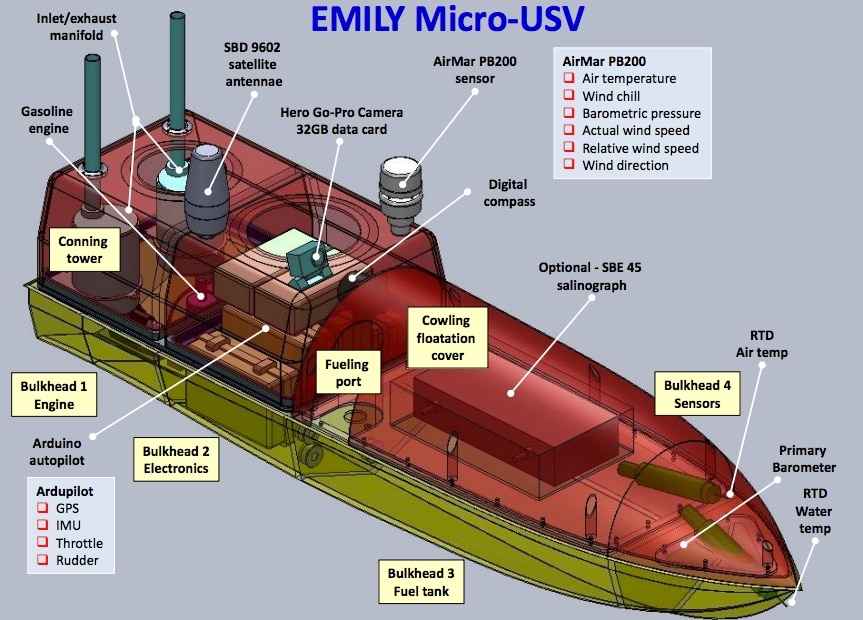
The modified EMILY vessel can track the eye of a hurricane. (Image Credit: NOAA)

NOAA’s re-engineered EMILY robot tracks the eye of a hurricane, making up for what the Wave Gliders cannot monitor. It has a gas-powered engine, a large fuel tank, and a battery. It’s still similar to the Gliders because EMILY also features air and water temperature sensors, barometric pressure indicators, wind speed sensors, a camera, and more. EMILY is often deployed ahead of an approaching storm and reaches its center, staying in place while streaming data as it passes.

EMILY focuses more on obtaining data about the pressure of the storm’s eyewall, which has thunderheads encircling the storm’s eye. A larger storm’s eyewall moves in cycles, which help determine whether or not a hurricane is gaining or losing strength.

image

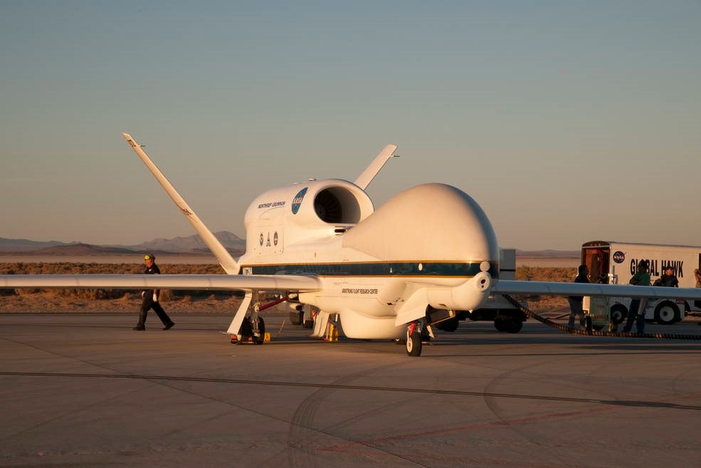
NASA’s Global Hawk drone drops canisters into a storm from above to collect data on humidity, temperature, pressure, and more. (Image Credit: NASA Photo / Lauren Hughes)

In 2016, NOAA began using a Global Hawk military-grade drone for storm tracking. It has a 26-hour flight time, enabling it to travel from NASA’s facility on the Virginia coast to Africa’s west coast. Global Hawk even has an airborne vertical atmospheric profiling system that drops canisters into a storm, collecting humidity, temperature, pressure, and other data. An NOAA worker stationed thousands of kilometers away can instruct the drone to drop the canisters just by clicking a mouse button.

The drone also features other instruments that generate real-time wind and precipitation 3D maps. Compared to other techniques, this has resulted in more accurate storm information while it develops.

Have a story tip? Message me at: http://twitter.com/Cabe_Atwell

  • Sign in to reply
element14 Community

element14 is the first online community specifically for engineers. Connect with your peers and get expert answers to your questions.

  • Members
  • Learn
  • Technologies
  • Challenges & Projects
  • Products
  • Store
  • About Us
  • Feedback & Support
  • FAQs
  • Terms of Use
  • Privacy Policy
  • Legal and Copyright Notices
  • Sitemap
  • Cookies

An Avnet Company © 2025 Premier Farnell Limited. All Rights Reserved.

Premier Farnell Ltd, registered in England and Wales (no 00876412), registered office: Farnell House, Forge Lane, Leeds LS12 2NE.

ICP 备案号 10220084.

Follow element14

  • X
  • Facebook
  • linkedin
  • YouTube