element14 Community
element14 Community
    Register Log In
  • Site
  • Search
  • Log In Register
  • Community Hub
    Community Hub
    • What's New on element14
    • Feedback and Support
    • Benefits of Membership
    • Personal Blogs
    • Members Area
    • Achievement Levels
  • Learn
    Learn
    • Ask an Expert
    • eBooks
    • element14 presents
    • Learning Center
    • Tech Spotlight
    • STEM Academy
    • Webinars, Training and Events
    • Learning Groups
  • Technologies
    Technologies
    • 3D Printing
    • FPGA
    • Industrial Automation
    • Internet of Things
    • Power & Energy
    • Sensors
    • Technology Groups
  • Challenges & Projects
    Challenges & Projects
    • Design Challenges
    • element14 presents Projects
    • Project14
    • Arduino Projects
    • Raspberry Pi Projects
    • Project Groups
  • Products
    Products
    • Arduino
    • Avnet Boards Community
    • Dev Tools
    • Manufacturers
    • Multicomp Pro
    • Product Groups
    • Raspberry Pi
    • RoadTests & Reviews
  • Store
    Store
    • Visit Your Store
    • Choose another store...
      • Europe
      •  Austria (German)
      •  Belgium (Dutch, French)
      •  Bulgaria (Bulgarian)
      •  Czech Republic (Czech)
      •  Denmark (Danish)
      •  Estonia (Estonian)
      •  Finland (Finnish)
      •  France (French)
      •  Germany (German)
      •  Hungary (Hungarian)
      •  Ireland
      •  Israel
      •  Italy (Italian)
      •  Latvia (Latvian)
      •  
      •  Lithuania (Lithuanian)
      •  Netherlands (Dutch)
      •  Norway (Norwegian)
      •  Poland (Polish)
      •  Portugal (Portuguese)
      •  Romania (Romanian)
      •  Russia (Russian)
      •  Slovakia (Slovak)
      •  Slovenia (Slovenian)
      •  Spain (Spanish)
      •  Sweden (Swedish)
      •  Switzerland(German, French)
      •  Turkey (Turkish)
      •  United Kingdom
      • Asia Pacific
      •  Australia
      •  China
      •  Hong Kong
      •  India
      •  Korea (Korean)
      •  Malaysia
      •  New Zealand
      •  Philippines
      •  Singapore
      •  Taiwan
      •  Thailand (Thai)
      • Americas
      •  Brazil (Portuguese)
      •  Canada
      •  Mexico (Spanish)
      •  United States
      Can't find the country/region you're looking for? Visit our export site or find a local distributor.
  • Translate
  • Profile
  • Settings
Sensors
  • Technologies
  • More
Sensors
Blog Scientists Have Discovered a Hidden Landscape Beneath an Ice Sheet in Antarctica
  • Blog
  • Forum
  • Documents
  • Quiz
  • Events
  • Polls
  • Members
  • Mentions
  • Sub-Groups
  • Tags
  • More
  • Cancel
  • New
Join Sensors to participate - click to join for free!
  • Share
  • More
  • Cancel
Group Actions
  • Group RSS
  • More
  • Cancel
Engagement
  • Author Author: Catwell
  • Date Created: 15 Nov 2023 7:42 PM Date Created
  • Views 519 views
  • Likes 8 likes
  • Comments 1 comment
  • sar
  • nature
  • space
  • radar
  • Antarctica
  • cabeatwell
  • satellite
  • earth
  • sensor
  • innovation
Related
Recommended

Scientists Have Discovered a Hidden Landscape Beneath an Ice Sheet in Antarctica

Catwell
Catwell
15 Nov 2023

image

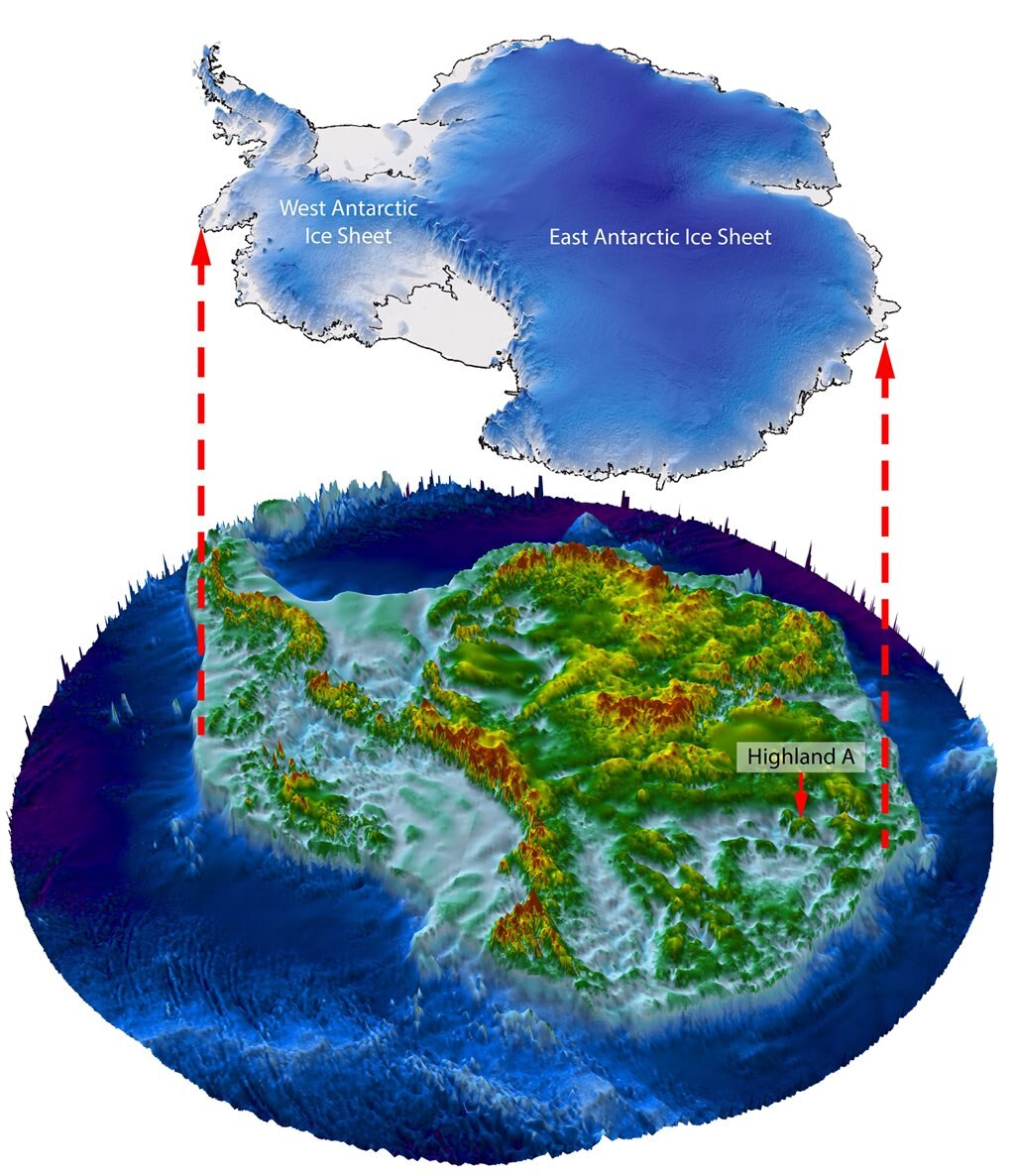
Scientists discovered a landscape hidden underneath an ice sheet in Antarctica. (Image Credit: Stewart Jamieson)

Scientists recently announced they found a hidden landscape featuring valleys and hills underneath a 1.6-mile deep ice sheet in Antarctica. The larger-than-Belgium landscape carved by rivers has been frozen in time for potentially 34 million years. However, the team believes their finding gives them insights into whether climate change could expose the landscape. The team revealed they relied on previously captured imagery from a trio of satellites called RADARSAT Constellation developed by the Canadian Space Agency and radio echo-sounding.

Usually, a plane equipped with ice-penetrating radar flies overhead landscape to map it out. But the ice sheet in East Antarctica is too big (32,000 km2) to rely solely on that technique. So, the team gathered images captured by the RADARSAT Constellation to trace the ridges and valleys. Overall, these satellites detect small anomalies in the ice surface, hinting at potential topographies.

At first, the image revealed the ice surface draping atop those features. After combining the satellite images with radio-echo-sounding data captured over the past few decades, a new image showed a landscape with valleys and hills shaped by rivers. They concluded that it looked very similar to the Wales' landscape.

image

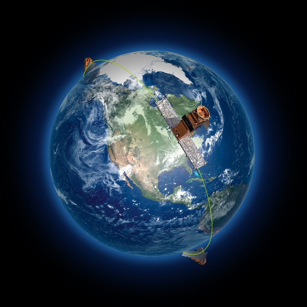
The three RADARSAT spacecraft image the Earth. (Image Credit: Canadian Space Agency)

The Canadian RADARSAT Constellation uses an advanced Synthetic Aperture Radar (SAR) to image Earth at a 5.405 GHz microwave frequency (C-band wavelength of 5.5 cm). It has a swath width of 20 to 500 km, which allows it to cover nearly all parts of the world in just four days if all three satellites operate in a low-resolution mode. Plus, the SAR module's imaging resolution is 3 to 100m and can perform left or right-hand variable pointing at a 350-500km wide field of regard. The SAR has single or dual-co-cross selectable polarization and compact polarimetry for all image modes. While the SAR has one quad-polarization mode, the dual HH-VV can be used for certain modes.

It also comes with three sensor modes for imaging: ScanSAR, Spotlight, and Stripmap. ScanSAR relies on two or more single beams that cover adjoining swaths. Each beam, which involves a series of pulse transmissions and receptions, operates consecutively. This enables data collection from a swath that's wider than a beam. Meanwhile, the spotlight electronically moves the beam on a targeted area, extending the aperture time that generates products in finer azimuth resolution. Lastly, the stripmap is the mode that ensures a constant beam elevation, operation, and profile.

Microwave energy sent by the SAR system bounces off the Earth's surface and gets captured by the receiver before being recorded. This allows the RADARSAT to image the Earth during the day/night despite the weather, like rain, snow, cloud, haze, or dust.

Scientists believe climate change could eventually expose the landscape. "We are now on course to develop atmospheric conditions similar to those that prevailed" between 14 to 34 million years ago when it was three to seven degrees Celsius warmer (roughly seven to 13 degrees Fahrenheit) than currently," they wrote in the paper.

But even then, the landscape is hundreds of kilometers away from the ice's edge, which means that exposure is still unlikely. There's still some hope because past warming events didn't expose it.

Have a story tip? Message me at: http://twitter.com/Cabe_Atwell

  • Sign in to reply
  • dougw
    dougw over 1 year ago

    The temperature under the ice in Antarctica can be above freezing due to Earth's hot core. The liquid lakes and rivers under the ice in Antarctica are teaming with life.

    An odd phenomenon is that some rivers may flow up hill due to pressure from the ice.

    • Cancel
    • Vote Up 0 Vote Down
    • Sign in to reply
    • More
    • Cancel
element14 Community

element14 is the first online community specifically for engineers. Connect with your peers and get expert answers to your questions.

  • Members
  • Learn
  • Technologies
  • Challenges & Projects
  • Products
  • Store
  • About Us
  • Feedback & Support
  • FAQs
  • Terms of Use
  • Privacy Policy
  • Legal and Copyright Notices
  • Sitemap
  • Cookies

An Avnet Company © 2025 Premier Farnell Limited. All Rights Reserved.

Premier Farnell Ltd, registered in England and Wales (no 00876412), registered office: Farnell House, Forge Lane, Leeds LS12 2NE.

ICP 备案号 10220084.

Follow element14

  • X
  • Facebook
  • linkedin
  • YouTube