


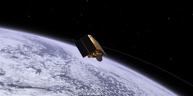
The Sentinel-6 satellite launched from Vanderberg Air Force Based in California. (Image Credit: NASA/JPL-Caltech)
While the climate changes, Earth’s oceans are rising and warming up. For three decades, satellites have been orbiting the Earth to monitor the seas. The most recent satellite, Sentinel-6 Michael Freilich, has started providing precise measurements of Earth’s rising sea level. The satellite, named after NASA’s late climate scientist Michael Freilich, launched from Vanderberg Air Force Base in California in November 2020.
While in orbit, Sentinel 6 is expected to give scientists more accurate data based on the ocean’s surface. Overall, measurements are expected to be a few centimeters more accurate. This allows meteorologists to improve weather pattern tracking for hurricanes and accurately monitor weather patterns, temperatures, and rising sea levels.
Sentinel 6’s mission has just started. "It's a relief to know the satellite is working and the data looks good," said Josh Willis, project scientist at NASA's Jet Propulsion Laboratory (JPL), in a statement. "Within a few months, he will take over from his predecessor, Jason 3, and this data release is the first step in that process."
The first image shows sea surface height. This data is overlaid on a map that shows similar recordings from the Jason 3, Sentinel-3A, and Sentinal-3B satellites. The background shows a map of sea-level anomalies from satellite data.
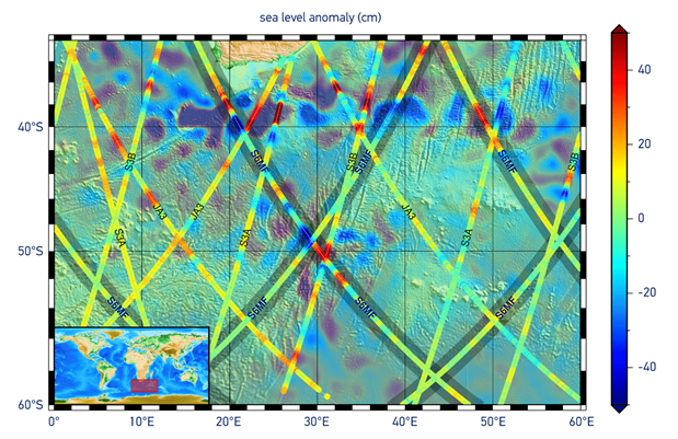
(Image Credit: ESA CC BY-SA 3.0 IGO)
Next, the following image shows satellite-processed data and downlinked (blue line) compared to ground-based raw data (red line). The data rate is reduced by 50% after the data’s trailing edge is removed before being sent to Earth.

(Image Credit: ESA/isardSAT, CC BY-SA 3.0 IGO)
The series of images below show Russia’s Ozero Nayval Lagoon and surrounding rivers. The first image was captured by Sentinel-2; the second one was capture from Sentinel-1; and the last one, which did not show a lot of data, was captured by Sentinel-6 in low-resolution mode.
(Image Credit: ESA/Aresys, CC BY-SA 3.0 IGO)
Sentinel-6 is the newest addition to a lineage of ocean observation satellites. The first satellite, TOPEX/Poseidon, was launched in 1992 to help scientists regularly study marine processes on a global scale. Then, three other satellites launched in 2001, 2008, and 2016 belonged to the Jason series. The last one, Jason 3, is still operational, focusing on sea-level measurements while assisting meteorologists. The measurements were first taken and provided by the TOPEX/Poseidon satellite. Data reveals that since 1993, the global sea level has risen by 3.2 mm per year on average. More alarmingly, the ocean level rose by 4.8 mm per year on average.
Sentinel-6 and Jason 3 scan 90% of the Earth’s oceans. Before Sentinel-6 takes over Jason 3’s role as the primary sea level monitoring satellite, scientists need to compare the data collected from the two. This ensures that it’s ready for the job.
Sentinel-6 also has a significant improvement over Jason 3: Poseiden 4, an advanced altimeter. Poseidon 4 takes more accurate sea surface height measurements compared to traditional radar altimeters. This is because it analyzes the radar signal’s Doppler Effect while bouncing off the sea surface and returning to the spacecraft.
Two Sentinel-6 satellite data streams are available to the public. They provide sea surface height data with accuracies of 5.8 cm and 3.5 cm. The final data stream is expected to become available later this year, which has an accuracy of 3 cm.
The next satellite, Sentinel-6B, is scheduled to launch in 2025, providing data in 2030. These are designed to last for five years but could provide data for a longer duration.
Have a story tip? Message me at: http://twitter.com/Cabe_Atwell